Nicholas Mirzoeff
Visiting Palestine was astonishing for the sheer intensity of the oppression. It was clarifying to see how the occupation operates and how little it cares what others think of it. It was humbling to see what being an activist really means and how privileged academic activism seems compared to the daily litany of harm to which any person in Palestine is exposed.
I saw elements of many different visual regimes struggling to cohere into what might become a new form. Surveillance is universal, but it’s not a panopticon because the jailers are all too visible. Religion is the justification for settlement, as it was under high imperialism, but there is no desire to convert the unbelievers. Counterinsurgency seeks “full spectrum dominance” but expects the insurgency to be permanent unless its conditions of possibility are removed.
The one thing everyone on all sides agrees on is that it’s all about land—who owns it, who can farm it, live on it, use the rainwater that falls on it, mine the minerals below—and so on. Whatever this is, it’s patently a form of colonialism. So, I decided to use my impressions to create an ABC of occupation.[1] Unlike Nicolai Bukharin’s classic ABC of Communism, this is not a program. It is a report back on the heart of visuality’s own contradiction. That is to say, Palestine is an actually existing possibility for the general condition of social life in the twenty-first century.
Perhaps the election of Donald Trump clarifies this issue somewhat. The complicated ways in which someone willing to discuss Palestine gets produced as anti-Semitic surely pale by comparison with the insertion of Stephen Bannon, an old-fashioned Jew hater into the White House.
Perhaps the success of a campaign based on the promise of a “beautiful” wall, xenophobia, hatred of Islam and Muslims and a willingness to separate existing populations will help people understand why Palestine is an example not an exception.
Perhaps.
A is for Area A
The regime covers the territory with signs, expressing its intent (fig. 1). These signs are posted wherever Area A, under the nominal control of the Palestinian Authority (PA), borders with what the regime considers to be the state of Israel. Apparently, the Hebrew and Arabic versions are at variance. The English message is clear: Palestinians are dangerous. Red alert. Less obvious is that Area A covers only 18 percent of what is still referred to as the “West Bank” in a series of increasingly isolated pockets, centered on the Palestinian cities like Ramallah and Nablus. No functional state can be made from these islands. The “two-state solution” is visibly impossible.

Although Area A signs are quite common, there are no others. Where do you enter Area B (largely considered defunct on the ground) and Area C, now considered to be some 63 percent of the West Bank? There are no signs other than the change of rules of engagement and the appearance of settlements, settler buses and the settlers themselves. Palestinians seem to know, as do the settlers and the Israeli Defense Force. So the Area A signs are really for people like me, or Israeli leftists, venturing into the West Bank. I don’t think they work. I hadn’t been there long before the sight of an Area A sign made me relax and feel safe.
B is for Benjamin
Here is a sign of colonialism if there ever was one (fig. 2). It depicts the wolf emblem of the tribe of Benjamin, one of the Twelve Tribes of Israel. Massive in size and posted high above the ground, it is positioned on the road from Jericho to Jerusalem, notionally running through Area C but extensively used by tourists going to the Dead Sea. However, according to legend, Joshua assigned this area to Benjamin. So what the sign indicates is that Oslo may have designated the land for Palestinians, but God had already given it to the Jews. Posted signs indicate that the area is officially known to the regime as Judea and Samaria. Benjamin’s land.
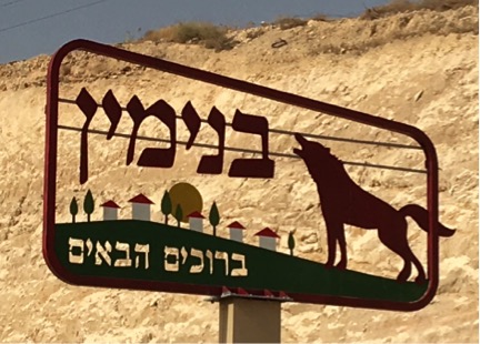
The Benjamin sign is only in Hebrew, a message for the colonists alone. But its visual message is clear enough. The howling wolf arcs his body over a cluster of white houses with red roofs, set against green grass and trees. The imperial echo of the Roman wolf cannot be missed. The empire protects. The houses are recognizably those of the illegal settlements that cover every hilltop in the West Bank, which all have such red roofs, in part to make them visible to the Israeli air force as settlements.
The grass and trees transform the scene into an evocation of American suburbia, the picket-fence view of the world. When I took this picture, the temperature was 115 farenheit (45 celsius). Any greenery in a Dead Sea settlement—and there is plenty—is both an ideological production and an environmental fabrication that relies on appropriated water. 10,000 settlers living in the Jordan Valley and Dead Sea area use one-third of the water accessible to the entire Palestinian population in the West Bank (estimated at over 2.5 million).
C is for City.
Cities are the testing ground for what is now in formation. Hebron, a notionally Palestinian city, has become the front line of settler colonialism in Palestine. The settlers are expanding, street by street, using their mix of the carceral state, religion and military force. To visit Shuhada Street, formerly a shopping hub of the Palestinian neighborhood, you have to pass through a forbidding checkpoint. The street is closed, all Palestinian shops barred and sealed. Settlers and soldiers patrol to make sure you know who’s in charge.
Although the street has been closed for years, it was nonetheless disturbing to see Stars of David painted on the closed doors, as if in active forgetfulness of those other times and places where such stars were painted on Jewish shops to different ends (fig. 3). More disturbing yet was the thought that perhaps the ends were not that different after all.

At that moment, a settler started to film us from the other side of the street. Losing my temper, I walked towards him, holding my phone so as to film him. He retreated, only to return with a soldier a few moments later. Nothing was said, but the point was made: we were photographing on their sufferance. We left in short order.
D is for Desert
In the Naqab desert (called the Negev by the regime and within what Palestinians call the forty-eight, meaning the 1948 border), Bedouins at the village of al-Aqarib told us how their village had been destroyed ninty-eight times by Israeli police (over one hundred times as of October 2016). Their crops have been sprayed with Round Up from the air. The Jewish National Foundation plants millions of trees over as much of the Bedouin land as they can, aided by well-meaning environmentally inspired donations from the United States and elsewhere.
The Bedouin’s animals are arrested as they graze by the Green Patrol—an ecological unit of the regime—and the Bedouin are forced to pay heavy fines to retrieve them. How so? The regime has declared 85 percent of the Naqab to be state land or environmental reserves, so any person or animal setting foot in these areas is trespassing. The camels are arrested just like anyone else. Despite these conditions, we were treated to a lavish and delicious meal at al-Aqarib, according to the dictates of hospitality. A week after we left, the structures were demolished yet again.
G is for Giraffe
The Palestinian scholar Rashid Khalidi has called Israel a “carceral state.” A metonym of this condition, and its complications, can be found at Qalqilya zoo. Qalqilya is almost entirely surrounded by the Separation Wall, as a result of its involvement in the first Intifada. Despite this embattled status, it has within it a zoo, one of the few functioning public leisure spaces I saw.
Like most zoos, its containment of animals is grim. A brown bear paced in his cage relentlessly, as if wanting the Palestinian visitors to see his confinement as their own. Most dramatic is the separate museum that contains a number of stuffed animals. They died in the Intifada, as in the case of the giraffe, who lay down in fear during gunfire, causing her to die from her own blood pressure (fig. 4).

It transpired that she was twelve months pregnant (out of fifteen), and so the zoo director, Sami Khader, turned taxidermist to preserve them. Their spindly bodies are perhaps indicative of his emergent skills or maybe testify to the emaciated condition of the animals under siege. You might see them as martyrs, nonhuman victims of the occupation, or as surrogates, waiting until Palestine is free to welcome other giraffes. It’s a poignant story, and there’s a film being made called Waiting for Giraffes and a published book called The Zoo On the Road to Nablus.
But there were very few visitors other than us to the museum, not least because there was an additional charge for admission. And then there’s always the occupation. During the Intifada the animals that did survive were forced to eat leaves from the trees and other local plants. At some point later, Dr. Sami (as he is known) decided to take animal food and other equipment from Israeli zoos. To do so is to break the boycott of Israel. Palestinians condemn his action.
Is sustaining a public resource and keeping animals alive a reasonable cause? Or is a boycott a boycott? Palestinians demonstrate time and again a long-term steadfast resistance, known as sumud in Arabic, to their own material and physical detriment. There is no simple and painless answer to this dilemma, which is the condition of being under occupation. The proper solution is, of course, an end to that occupation.
S is for Settlement
Perhaps the strongest impression that a visitor to Palestine receives is how many settlements there are in the West Bank. No one should imagine that they all can be removed in some future two-state solution. That’s why I initially put West Bank in quotation marks: there is no West Bank. As we were driving, we once went into a valley where there was no settlement. Surprised, I glanced at my watch. It was twenty-five seconds before the next settlement became visible.
Settlement landscape in Palestine is not hard to read because it is intended to dominate and intimidate (fig. 5). The settlements occupy hilltops to command a dominant viewpoint all around. The windows of the buildings face out to have as many eyes engaged in this monitoring as possible. They are close together for supposed safety, built behind defensive walls on land cleared of trees. There’s little left to tell you that Palestinians once farmed the land. Even the slow-growing olive trees have been cleared to make way for fast-growing pines.
The pines are cultivated for timber, but they also serve to make the settlements look established. And they remove a resource from Palestinians. Locals told us that the Israelis had sedated and removed even the local wildlife, like deer and eagles. I have not been able to independently verify this account, but the absence of wildlife was notable.
In this valley, though, one farmer has kept a foothold. Using Ottoman-era documents to demonstrate ownership, the family has been able to cling to their land. Their goat pen is visible at bottom left. Thousands more were not so “lucky.” Their land is gone, appropriated or made useless. The Bedouin at al-Aqarib have similar documents that have not helped them.
T is for Tell es Sultan
A ‘tell’ is the name for an archaeological mound created by an abandoned human occupation (fig. 6). In Tell es Sultan, just outside Jericho, the British architect Kathleen M. Kenyon excavated human settlements reaching back to 10,000 BCE. That’s the very beginning of the Holocene, the now concluded window in which stable climatic conditions allowed for settled agriculture and what we call civilization.
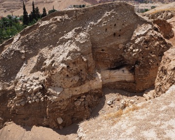
Kenyon’s signature “stratigraphic” style allows us to see the unfolding of human possibility from that early period, via the Neolithic, Bronze, and Iron Ages to the Romans. Her vertical method emphasizes these changes over time, rather than allowing for a horizontal exploration of how people lived in any one epoch. The discoveries of tombs on the north side of the site were in fact made by Palestinians from the ‘Ein-as-Sultan camp that held 20,000 refugees after 1948. In 1967, all but a thousand or so were expelled into Jordan. The British Museum where some of Kenyon’s objects are now housed makes no reference to the Palestinian role in discovering the tombs or to the camp, which is visible if you know where to look in the site photograph provided. No one does, they all rush past to get to the Egyptian “mummies,” human remains on display for tourist consumption.
Everything changes. An urban civilization fell circa 2530 BCE. It was not restored until 1900 BCE. The big white tourist buses arrive and take a look at what they incorrectly believe to be the fallen walls of Jericho and leave. When you look up at the mountains above you realize what a mote in the eye of geological time these little ripples have been.
Q is for Qalqilya
Everywhere you look in Palestine, there’s detritus—discarded packaging, demolished housing, unfinished settlements, abandoned cars, electrical components, and trash and waste of all kinds. In Area C, most of the West Bank, no one is authorized to pick up trash—the PA has no authority, and the IDF could care less. In the refugee camps the United Nations steps in. Elsewhere, it piles up or people burn it, contributing to the omnipresent smog.
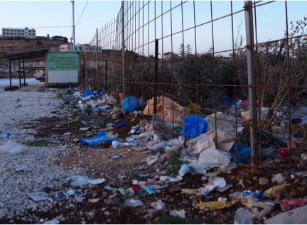
At the Qalqilya checkpoint at the end of the day, after the last few workers have returned around 7:30 at night, crossing back into Palestine from Israel where they work, no one hangs around (fig. 7). To be sure of getting through in time for work, people will begin queuing again at 2 a.m. to be well-placed when the checkpoint opens at six. It processes one person at a time. Around four thousand will go through.

And so coffee cups, soft drink bottles, bus tickets, and candy wrappers pile up, signs of lives lived in transit (fig. 8). As they sediment into the ground, the impermeable plastics and metals will await some future archaeologist, one who will note with surprise the sudden collapse of a short-lived but apparently consumer-oriented society. They will puzzle over the fences and walls; what purpose could they have served? Perhaps a new legend, like that of Joshua and the walls of Jericho will have been created. It’ll be a long wait for these new investigators; evolution takes place in deep time. The plastics, metals, and rocks won’t mind.
Acknowledgements
I visited accompanying the art activist group MTL and with the generous support of many Palestinians, especially Habshe Yossef. I would also like to acknowledge the decolonial activist group Zochrot for arranging my meeting at al-Aqarib. The full web project is still being worked on by techs at USC for security. When available it will be here. For the time being I have made a PDF of the project that you can access, with either the full text or just the introduction.
That said, all the opinions expressed here are mine alone.
[1] These are selected entries from the full ABC available at scalar.usc.edu/nehvectors/mirzoeff/index


Pingback: How to See Palestine: An ABC of Colonialism | MadisonRafah.org
The ‘imperial wolf of Rome’ showed early on that as with many critics of Zionism, there is no substantial working knowledge about Jewish culture or history pre-1948 whatsoever. Instead the antiquity of Jewish occupation is dismissed completely. It’s a strange thing about being Jewish; people say we don’t belong anywhere, that we’re a tribe but not indigenous. How could that be?